Olympics 2026

Milano Cortina - Offical Partner for Olympics and Paralympics 2026

4.2 North on the Sarca cycle path: from Arco to Sarche

Cycle routes

Cycle routes recommended route

4.2 North on the Sarca cycle path: from Arco to Sarche

Cycle routes · Garda Lake Open
Logo Garda Trentino
Responsible for this content
Garda Trentino Verified partner 
  • The Roman Bridge in Ceniga
    The Roman Bridge in Ceniga
    Photo: Archivio Garda Trentino, North Lake Garda Trentino

Selected alternatives for you
    A route which is almost entirely on the cycle path along the banks of the River Sarca, one of the best-loved in Trentino and busy all year round.
    Open
    moderate
    Distance 38.3 km
    2:55 h
    228 m
    227 m
    276 m
    86 m
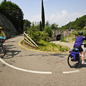
    The cycle path from Torbole to Sarche is the most popular in Trentino: every year thousands of cyclists and hikers pass this way. The track starts from the lake shore in Torbole and follows the River Sarca upstream on a flat route which winds through the countryside. The stretch as far as Dro is particularly suitable for families with small children who want to explore Garda Trentino by bicycle.

    Author’s recommendation

    In summer be sure to bring your swimsuit: underneath the Roman bridge in Ceniga there is a little beach, ideal for cooling down after your bicycle ride
    Profile picture of Staff Outdoor Garda Trentino VB
    Author
    Staff Outdoor Garda Trentino VB 
    Logo Garda Trentino
    Responsible for this content
    Garda Trentino  Verified partner 
    Difficulty
    moderate
    Overall difficulty
    moderate

    Derived from the technical difficulty and the stamina requirements.

    Experience
    Landscape
    Highest point
    276 m
    Lowest point
    86 m
    Best time of year
    Jan
    Feb
    Mar
    Apr
    May
    Jun
    Jul
    Aug
    Sep
    Oct
    Nov
    Dec

    Track types

    Show elevation profile

    Safety information

    Safety Tips

    1. Always wear your helmet.  
    2. Plan your ride.  
    3. Obey the road signs, stop at traffic lights and do not ride on the wrong side of the road.  
    4. You share the trail with other users. Yield right of way to hikers.  
    5. Respect public and private property.  
    6. Do not cycle solo in remote areas. 
    7. Make sure your bike lights are working. 

    This information is subject to inevitable variations, so none of these indications are absolute. It is not entirely possible to avoid giving inexact or imprecise information, given how quickly environmental and weather conditions can change. For this reason, we decline any responsibility for changes which the user may encounter. In any case, it is advisable to check environment and weather conditions before setting out. 

    Tips and suggestions

    • After Pietramurata the cycle path winds through many vineyards: you are in the area where Vino Santo is produced, a Slow Food presidium of the upper lake. It is a sweet wine produced in limited quantities from the indigenous Nosiola grape and is traditionally pressed on Good Friday, or Venerdì Santo. 


    You’ve already picked your cycling route—now all you need is the right support. Discover all the Bike Specialists in Garda Trentino: rentals, repair shops, and dedicated bike stores are ready to welcome you right here. 

    Public transport

    Public-transport-friendly

    Arco is served by a number of bus lines, in particular the two urban lines (numbers 1 and 2) which connect Riva del Garda with Torbole sul Garda. For bus times: www.gardatrentino.it

    Get Timetable to destination

    to
    4.2 North on the Sarca cycle path: from Arco to Sarche

    Directions

    From the toll-booth Rovereto Sud - Lago di Garda nord, take SP 3 and then strada statale 204 as far as Nago. From there, ss 240 in the direction of Arco. Further info about how to get to Garda Trentino: www.gardatrentino.it 

    Parking

    Parking place at the bridge (not free) 

    Coordinates

    DD
    45.920886, 10.889640
    DMS
    45°55'15.2"N 10°53'22.7"E
    UTM
    32T 646526 5086993
    w3w 
    ///maids.corks.juvenile
    Get there by train, car, bike, or on foot!

    Author’s map recommendations

    •  Bike Garda Trentino Map – On sale in tourist information offices in Riva del Garda, Arco and Torbole and online

    Equipment

    Riding your bike requires specific clothing and equipment, even for relatively short and easy trips. It is always better to be prepared… e.g. for bad weather or a sudden drop in your energy levels. The unexpected things are part of the fun!

    Remember to thoroughly evaluate the type of route you plan on doing, the locations you intend to cross and the current season. Has it been raining? Attention: The paths may be slippery and require more caution.

    What do I need to bring on my bike tour?

    • An adequate water supply according to your needs (considering temperature, possibility of refuelling and duration of the route)
    • Plenty of snacks (for example, dried fruit or energy bars)
    • Waterproof / Windproof jacket
    • A spare top / spare socks (Descending in a sweaty garment, will make you cold).
    • Suncream
    • Sunglasses
    • Bike gloves/mitts
    • Map or GPS device
    • Bike lights: best placed on your helmet or handlebars. (It is always best to be prepared)
    • Bike repair kit for punctures and mechanical breakdowns
    • First aid kit
    • Emergency whistle

    It is always advised to let someone know where you plan to go and how long you expect to be.

    Emergency telephone number 112.

    Similar routes nearby

    • 4.The Sarca Valley and Lake Cavedine: from Arco to Sarche
    • Along the Sarca cycle path: from Arco to Fies
    • Garda Trentino Discover
    • In the heart of Garda Trentino: the "Giro della Busa" loop
    • Garda Cycle Route: Riva del Garda – Sperone
     These suggestions were generated by our system
    Status
    Open
    Difficulty
    moderate
    Overall difficulty
    moderate

    Derived from the technical difficulty and the stamina requirements.

    Distance
    38.3 km
    Duration
    2:55 h
    Ascent
    228 m
    Descent
    227 m
    Highest point
    276 m
    Lowest point
    86 m
    Public-transport-friendly Round trip Scenic Refreshment stops available Geological highlights

    Weather at the starting point

    10-day forecast

    Statistics

    • Content
    • Show images Hide images
    Features
    2D 3D
    Maps and trails
    Nothing selected - click and drag in the elevation profile to zoom
    Distance
    Duration
    Ascent
    Descent
    Elevation profile


    You may also like ...

    45 results
    Pieve di Ledro | © Garda Trentino

    Biking round Lake Ledro

    Ciclabile Dermulo - Taio - Sabino | © APT Val di Non

    Ciclabile Dermulo - Taio - Sabino

    Cycling in Val di Fiemme | © APT Fiemme Cembra

    Easy Bike Ring - blue bis

    The cycle path near Passo San Giovanni | © North Lake Garda Trentino

    Adige Garda Cycle Path

    The cycle path in Torbole, beside the beach | © Garda Trentino

    Around Monte Brione

    View over Pranzo | © North Lake Garda Trentino

    From Lake Tenno to San Martino archeological site in Campi

    The Marocche area (on the right, in the background, lake Cavedine) | © Garda Trentino

    4.The Sarca Valley and Lake Cavedine: from Arco to Sarche

    The cycle path along the lake shore in Torbole | © Garda Trentino

    In the heart of Garda Trentino: the "Giro della Busa" loop

    Pieve di Ledro | © Garda Trentino

    Biking round Lake Ledro

    Ride for the whole family along the shores of Lake Ledro, among the...

    Read more ...
    Ciclabile Dermulo - Taio - Sabino | © APT Val di Non

    Ciclabile Dermulo - Taio - Sabino

    Questo tratto di ciclabile è pensato per collegare in modo sicuro la...

    Read more ...
    Cycling in Val di Fiemme | © APT Fiemme Cembra

    Easy Bike Ring - blue bis

    Route connecting the town of Cavalese to its hamlet, Masi di Cavalese.

    Read more ...
    The cycle path near Passo San Giovanni | © North Lake Garda Trentino

    Adige Garda Cycle Path

    Itinerary along the cycle path which links Vallagarina (in...

    Read more ...
    The cycle path in Torbole, beside the beach | © Garda Trentino

    Around Monte Brione

    This itinerary is perfect for a relaxing ride in a flat area near to...

    Read more ...
    View over Pranzo | © North Lake Garda Trentino

    From Lake Tenno to San Martino archeological site in Campi

    This short itinerary, all uphill, brings you to the hamlet of Campi,...

    Read more ...
    The Marocche area (on the right, in the background, lake Cavedine) | © Garda Trentino

    4.The Sarca Valley and Lake Cavedine: from Arco to Sarche

    This route takes you on a tour of the northern part of Garda...

    Read more ...
    The cycle path along the lake shore in Torbole | © Garda Trentino

    In the heart of Garda Trentino: the "Giro della Busa" loop

    An excursion among olive groves and vineyards, suitable for everybody...

    Read more ...