The Dürer Promenade in Arco
Hiking trail • Garda Trentino and Valle di Ledro
The Dürer Promenade in Arco
<p>A walk from the centre of Arco to Varignano, in the footsteps of the painter Albrecht Dürer who at the end of the 15th century was inspired by these places to paint the castle and town.</p>
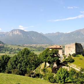
<p>This itinerary follows in the footsteps of the Nuremburg artist Albrecht Dürer through the olive groves of Arco to the point where he painted his famous view of the town, immortalising the castle surrounded by the medieval village and olive groves.</p> <p>Dürer visited this town on Lake Garda on the way back from his first Italian journey (1494), which he embarked on in order to get to see the artistic innovations introduced during the Renaissance. His destination was Venice and he probably moved around from there to other towns in northern Italy where he could examine the works of masters of the period such as Mantegna, Carpaccio and the brothers Giovanni and Gentile Bellini.</p> <p>The path is accompanied by some of the writings of Italian authors of the period (Nicolò d’Arco, Jacopo Vargnano), which give us an idea of the amazement felt by a traveller from the North looking for the first time on a country with a Mediterranean atmosphere and landscape.</p>
The Dürer Promenade in Arco

Garda Trentino Verified partner
A walk from the centre of Arco to Varignano, in the footsteps of the painter Albrecht Dürer who at the end of the 15th century was inspired by these places to paint the castle and town.
This itinerary follows in the footsteps of the Nuremburg artist Albrecht Dürer through the olive groves of Arco to the point where he painted his famous view of the town, immortalising the castle surrounded by the medieval village and olive groves.
Dürer visited this town on Lake Garda on the way back from his first Italian journey (1494), which he embarked on in order to get to see the artistic innovations introduced during the Renaissance. His destination was Venice and he probably moved around from there to other towns in northern Italy where he could examine the works of masters of the period such as Mantegna, Carpaccio and the brothers Giovanni and Gentile Bellini.
The path is accompanied by some of the writings of Italian authors of the period (Nicolò d’Arco, Jacopo Vargnano), which give us an idea of the amazement felt by a traveller from the North looking for the first time on a country with a Mediterranean atmosphere and landscape.
Author’s recommendation
Curious fact: in the rock of the cliff in the painting, the profile of a human face can be seen. Can you make it out?
The view of the castle of Arco appears in Dürer's watercolour “Venediger Klausen”, today housed in the Louvre. This “portrait” captures the rock of the cliff, the fortified town and the silvery hue of the foliage of the olive trees in quasi-photographic detail. The composition is an ideal one however, bringing together on a single canvas elements of the landscape and views which are actually quite far apart from one another.
Garda Trentino Verified partner
Derived from the technical difficulty and the stamina requirements.
Track types
Safety information
The telephone number for the emergency services is 112.
The information on this chart is subject to inevitable variations, so this means that none of the indications are absolute. It is not entirely possible to avoid giving inexact or imprecise information, given how quickly environmental and weather conditions can change. For this reason we decline any responsibility for changes which the user may encounter. In any case, the hiker is advised to check the conditions of the places, environment and weather before setting out.
Tips and suggestions
You’ve picked the perfect trail – now make sure you’re ready to enjoy it to the fullest. Local hiking specialists are here to help: guides, shops and experts with the tips and support you need for every step of the way.Public transport
Public-transport-friendly
The main towns in Garda Trentino - Riva del Garda, Arco, Torbole sul Garda, Nago – are connected by several urban and intercity bus lines which will take you to the starting point of tours or in the immediate surroundings.
You can also get to Riva del Garda and Torbole sul Garda by the public ferry service.
Up-to-date information on timetables and routes.
Get Timetable to destination
Directions
A22 Motorway, exit: Rovereto Sud - Lake Garda. Then SS240 in the direction of Arco.
Find out how to reach Garda Trentino.
Parking
Parking in Caneve (5 minutes walk to the town centre).
Paid parking: Foro Boario, near the bridge (Via Caproni Maini) or the post office (Via Monache).
Coordinates
Author’s map recommendations
Garda Trentino TREKKING Map – Available in the info points of Garda Trentino (Riva del Garda, Arco, Torbole sul Garda, Ledro, Comano Terme)
Equipment
This excursion is quite simple and presents no particular difficulty. However, we still recommend you to wear suitable footwear, a hat, sun screen and sunglasses. And be sure to bring water!
Localization
Derived from the technical difficulty and the stamina requirements.


